“OSM is to cartography what Wikipedia is to knowledge” A quote from the linuxfr.org forum. Built by a community of volunteer contributors, OpenStreetMap is today without a doubt a real gold mine. Whether you are a geogeek, a developer or a simple user of mobility applications, discover through our infographic of the month the reasons for OpenStreetMap’s success. The world’s largest VGI (volunteered geographic information) today used by major organizations such as Uber, Baidu Maps, Apple Maps, Bing Maps, Air France and the United Nations.
More than 7.5 million members
In 2004, Steve Coast, a British engineer, launched OpenStreetMap in order to bypass the excessive costs of using cartographic data in England. Indeed, before, only the Ordnance Survey, the cartographic service of the State was in charge of the cartography of the country. As stated in a 2007 article by the founder of OSM, “Even when you get your hands on that data you can’t do much with it due to lots of license restrictions.”
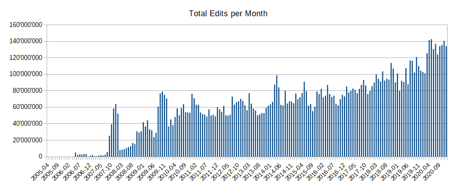
Quite the opposite with OpenStreetMap which has completely revolutionized this model. Indeed, like Wikipedia, the latter allows consultation, modification, use and exploitation, provided that OSM and its contributors are credited.” Living in the four corners of the world, more than 7.5 million volunteer contributors share a common goal. Namely, to offer open map data, available under the Open Data Commons Open Database License (ODbL). A license granted by the OpenStreetMap Foundation (OSMF). Fed and updated daily, OSM is no less than 4.5 million changes per day. With last February 25, 100 million changes reached, since its launch.
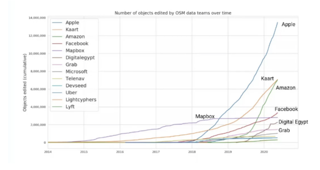
Nearly 17% of modifications made by companies
A curve in full expansion, especially with the arrival in 2014 of large private groups. Such as Uber, Grab, Microsoft, Amazon, Facebook, Apple or MapBox & Development Seed. Indeed, according to the article published in the ISPRS International Journal of Geo-Informationces, in the last 5 years, the number of contributing companies has increased from about ten to more than 1000. With for example Apple which went from less than 2 millions to nearly 15 millions modifications in 2 years.
Curious Cases of Corporations in OpenStreetMap by Jennings Anderson and Dipto Sarkar
A rise explained due to the fact that companies are investing and hiring their own editors. As an example, in 2019 the social network Facebook has deployed a tool based on machine leaning, to map better and faster. Emerging from the Map with AI project, it would have notably allowed to import in a few days more than 300,000 miles of roads in Thailand. Or even more than 21500 roads following a serious flood in Kerala, India. Another example, with Apple being one of the largest private contributors. Indeed, in 2019 the group has dedicated more than 340 people to update OSM.
More than 8.5 billion GPS points
On foot, in a wheelchair, on two wheels, in a train, in a bus, on skis, in a plane, in a boat… OSM is able to adapt to all modes of transportation. And this thanks to the characteristic elements of the OSM system (called iD) :
- the node, consisting of a longitude and a lattitude allowing to indicate an object such as a business or a road sign or a tree.
- the way, used to indicate roads, railroads or waterways
- Relations, used to connect certain lines
- And finally tag to qualify an object as well as possible. Such as the number of floors of a building.
As of March 1, 2021, OpenStreetMap has over 6.7 billion nodes. More than 746 million paths and over 8.7 million relationships. Representing in 2017, nearly 83% of the completed road network, according to a research paper by Christopher Barrington-Leigh & Adam Millard-Ball. Data estimated in mid-2020 to be worth more than $1.67 million according to an Accenture report. To find out more, we invite you to take a look at our infographic on the subject.