With nearly half of the world’s population confined, many route planning services have had to rethink their application. Indeed, in order to allow their users to limit and facilitate their trips, new functionalities have been developed. From locating restaurants that deliver to homes, to COVID-19 screening centers, to providing transport on demand, an overview of the new functionalities of Google Maps, Apple Plans, Waze, Moovit and Citymapper.
List of restaurants that deliver on Google Maps
Since the start of COVID-19, Google has recorded an 88% drop in the number of visitors to entertainment venues (restaurants, cinemas, etc.) in France, and a 72% drop in trips to food and drug stores. In order to limit travel as much as possible, Google has recently added new filters to its search. If you’re used to planning your trips with Google Maps, you’ve probably noticed the new “Takeaway” and “Delivery” tabs. Alphabet’s subsidiary has decided to highlight restaurants that continue to deliver or offer take-out on its home page, just below the search bar.
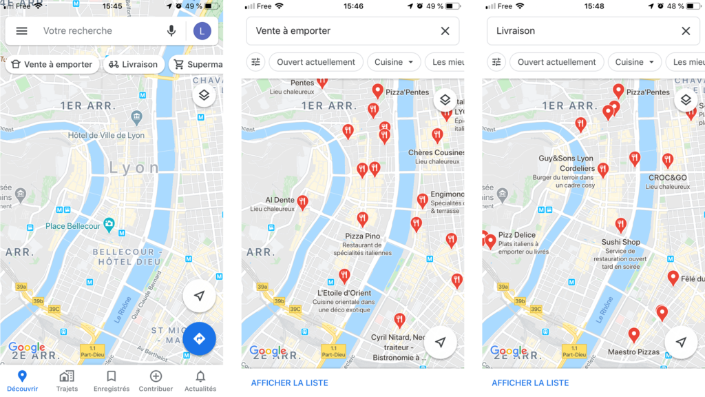
By clicking on one of the tabs, we access the complete list of restaurants. These are classified according to their distance, from the nearest to the furthest away. You will find their phone number, hours, as well as the list of favourite dishes or your match score. In addition, for some restaurants, you can also order directly on Google Maps. This saves the user from having to use third-party delivery services such as Uber Eats or Deliveroo.
Testing centers on Apple Plans
Just like its competitor Google Maps, Apple Plans has also recorded a drop in the use of its application. Indeed, we can see on their dedicated page COVID-19, since January 13, Apple Plans has recorded a drop in route searches of 87% among public transport users, 86% on the pedestrian side and 76% among motorists. In order to continue to make it easier and more convenient for people to limit their travel, Apple is working hard to effectively combat the coronavirus.
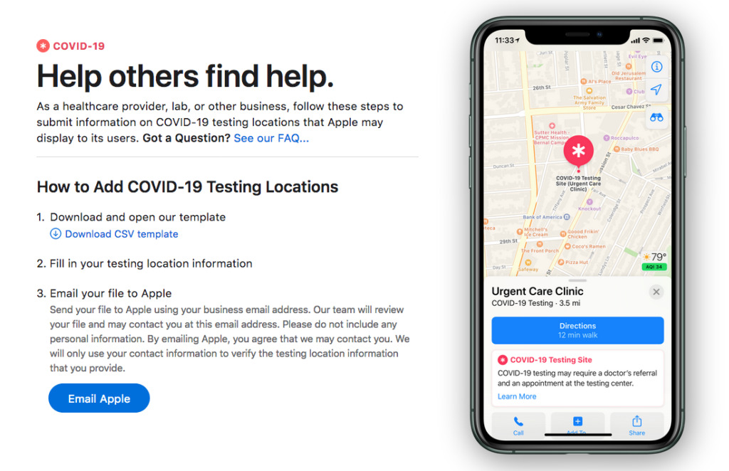
In collaboration with laboratories, pharmacies and clinics, the apple brand wishes to highlight establishments offering COVID-19 testing. The latter will have to send Apple their information sheet. Once referenced, the user will be able to locate these sites. They are identified by a red pictogram, already used to display health facilities. Note that some of these establishments will offer test delivery. For the time being, the date of the launch of this functionality has not yet been communicated. But we assume that it should be available very soon, given the scope of the situation.
Click & collect drives and shops on Waze
With an 83% drop in the number of searches for routes in France, Waze is also facing this health crisis. The addition of a “general containment” popup in France as soon as the application is opened. Drive only when absolutely necessary. In this case, take your certificate of derogatory travel with you. “Waze is constantly putting in place measures to encourage users to limit their movements as much as possible. Indeed, it has recently decided to withdraw the possibility of reporting the geolocation of law enforcement controls.
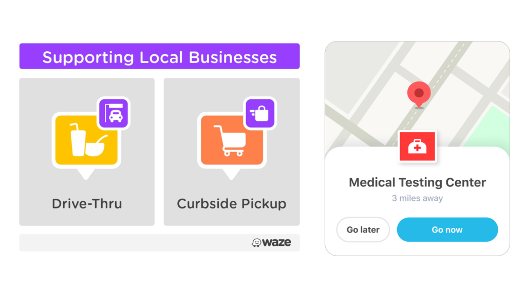
Last announcement less than a week ago, with the addition of the location of the businesses doing drive-thru and curbside pickup. Calling on its community, partners and governments around the world, Waze is constantly seeking to update its maps. Like Apple, Waze also reports the location of testing centers. But also emergency food distribution points or closed roads. In the United States, the application has partnered with WhyHunger and No Kid Hungry. It has thus been able to add more than 30,000 emergency food distribution points to its maps.
The implementation of an on-demand service on Moovit
As we saw in our infographics “COVID-19, transport and pollution: what lessons can be learned from this crisis? “Moovit has also observed a sharp drop in public transport ridership. Indeed, let’s take the case of France. Public transport recorded an 87.21% drop in average traffic. In order to help people unable to telework, Moovit has launched an on-demand emergency mobilisation service.
How does it work? By transforming the currently unused bus fleets into a transit-on-demand service. This is to ensure the home-to-work journeys of healthcare staff, supermarket employees, etc. While complying with government regulations. Users of the application will be able to request an on-demand transport immediately or at a later date. All they have to do is select their place of departure and arrival.
In addition, Moovit offers transport operators the possibility to use its “Transit Data Manager” service free of charge for 3 months. This tool allows them to quickly and easily communicate all changes related to COVID-19: timetables, routes, etc.
Public transport data constantly updated on Citymapper
Since the beginning of the pandemic, the multimodal application has seen a decrease in the use of almost 96%. 4% active users compared to a normal day in Milan, 5% in Madrid, 6% in Paris, 6% in New York, 10% in London, 13% in Montreal, 14% in Sydney, 15% in Berlin, 27% in Stockholm, 42% in Hong Kong,… These data, taken from the Citymapper Mobility Index, demonstrate the strong impact of containment on travel habits.
Recognized as one of the best urban mobility applications, Citymapper must continue to update its services during this period of COVID-19. Bus, tram and metro timetables are constantly updated in the 41 major cities where the application operates.
